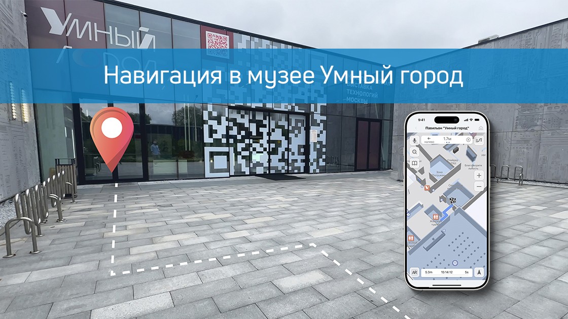
What happens if you combine the museum with smart city technologies? The Smart City pavilion at VDNH will turn out to be a living laboratory of the future, where we, the company Indoors Navigation, have implemented one of the most comprehensive projects of digital transformation of the exhibition space.
In this video, we will show how modern navigation and positioning technologies create a fundamentally new experience for visitors and provide powerful management tools for the administration.
You will see how it works.:
🗺️ A single geographic information system based on the digital twin of the entire pavilion. 📱 A mobile application with intelligent navigation and AR routes. 🎧 A "smart" audio guide that automatically turns on at the desired exhibit. 👁️ A video tracking and analytics system for managing visitor flows. 🌐 A virtual 360° tour that allows you to plan a visit from home.
Our project is not just a map in your phone. It is a complex ecosystem that makes visiting a museum a fascinating journey, and its management is efficient and data-oriented.
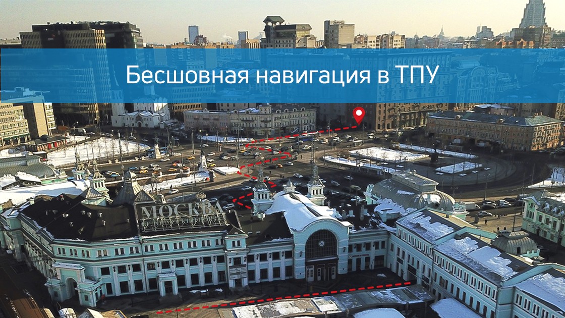
In the heart of any megalopolis, where the flows of people, trains and cars intersect, the main challenge of modern urbanism arises — the problem of orientation. The Belorussky transport hub in Moscow is not just a point on the map, it is a complex organism that unites the metro and railway stations of the same name, ground transport stops, underpasses and a well-developed infrastructure of services. Hundreds of thousands of people pass through it every day, and for many, this experience is associated with stress, loss of time, and the need to constantly switch between maps, signs, and questions from passersby. Indoors Navigation has taken on the ambitious task of turning this maze into a transparent, intuitive digital environment where navigation becomes seamless, continuous and completely natural.
From an architectural maze to a digital twin
The first and most difficult stage of the project was to create a high-precision digital copy of the entire TPU. Our engineers and cartographers have carried out extensive work on laser scanning and photogrammetry in order to digitalize not only the room plans, but also all their spatial characteristics. We have digitized the multi-level metro lobbies with their complex passageways, waiting rooms and platforms of the railway station, underground pedestrian galleries, exits to city streets and even the location of turnstiles, elevators and escalators. The most important part of the work was the inclusion of all significant points of interest in the general map — from cafes and shops to ATMs, storage rooms and toilets, because for a person the ultimate goal of the route is often not an abstract geo-coordinate, but a specific place where you can satisfy your need.
The result of this painstaking work is not just a map, but a complete digital model that understands the logic of human movement. The system knows that to switch from the Kazan direction to the Tagansko-Krasnopresnenskaya metro line, you need to go up to the second floor and go through an underpass, and it can calculate the time of this route taking into account the workload of the halls and the speed of the escalators. It takes into account which exits are open at different hours, and can warn the user that the lobby closest to his destination is closed for renovation, suggesting the best alternative way.
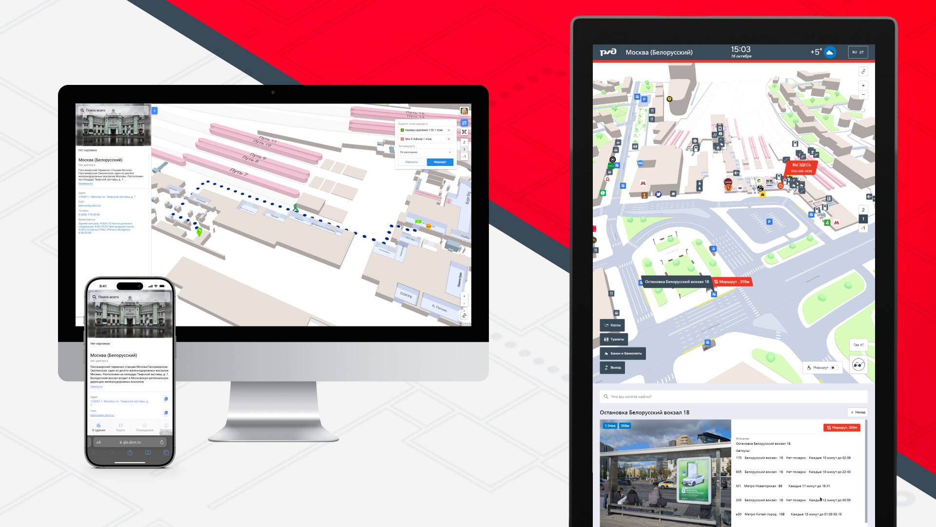
Three faces of one system: application, terminal and web
The key philosophy of the project was versatility and accessibility. We understood that different users prefer different channels of information in different situations, so the navigation system was implemented in three complementary formats synchronized with each other in real time.
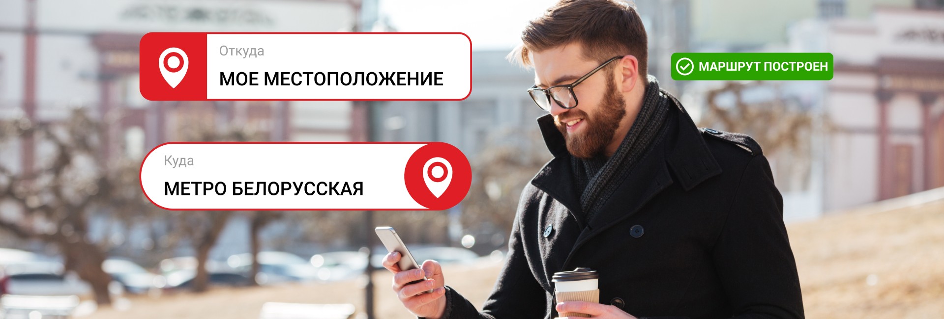
The mobile app It has become a personal guide for regular TPU users. Integrated with urban transport applications, it allows you to build a door—to-door route, for example, from a house in the Moscow region to a specific office on Leningradsky Prospekt, taking into account all transfers. The uniqueness of the solution is that at the moment when a person goes down to the subway or enters the station building, the application does not lose it, as happens with GPS navigators, but smoothly switches to using indoor positioning technologies, continuing to guide him through the same interface, with the same voice, with the same accuracy..
Information terminalslocated at key points of the hub — at the entrances to the subway, in the central halls of the station, at the exits to the platforms — have become a salvation for tourists, people without smartphones or those who just want to quickly navigate the place. Touch kiosks with large screens allow you to find the right service in a few taps or set a route to any point of the TPU. The terminal system forms its own network, where each kiosk knows its location, which allows it to offer the most relevant routes from exactly the point where the person is located.
Web version Navigation, accessible from any browser, has become a trip planner for those who like to prepare in advance. A potential passenger can study the TPU circuit from home or office, understand where to get off the train in order to get to the right metro lobby faster, and even "walk" along the future route in 3D mode in order to feel confident in reality.
Use cases: from daily routes to emergency situations
The real value of seamless navigation is revealed in the specific scenarios that are played out daily within the walls of the Belarusian TPU.
For a hurrying passenger, the system becomes a time-saving tool. An office worker who is late for morning planning can still set a route to the exit to Butyrsky Val Street in the aeroexpress carriage, and the application will take him the shortest way, bypassing the crowds of tourists at the main entrance to the metro, warning that there is increased traffic at the junction between stations today and it is better to go up to the floor above. According to our data, using optimized routes allows you to save an average of 5-7 minutes per transfer, which adds up to several saved hours per month.
For the tourist , navigation becomes a guarantee of peace of mind. A foreigner who finds himself at the Belorussky railway station for the first time no longer feels lost. He can find on the map not only a storage room for his suitcase, but also a currency exchange point with the best exchange rate, and from there he can be guided to the bus stop he needs. Integration with the machine translation system in terminals makes navigation available in dozens of languages, erasing the language barrier.
For people with limited mobility, the system provides an accessible route function. When building a path, it takes into account the presence and working condition of elevators, ramps and lifts, allowing a person in a wheelchair or with an injury to the musculoskeletal system to reach the goal without unforeseen obstacles.
For the TPU administration, the collected anonymized data on human flows is an invaluable tool for managing infrastructure. Analytics shows where traffic jams occur regularly, which exits are being used inefficiently, and how flows can be reallocated to increase the overall throughput of the node. This allows not only to increase security, but also to place commercial outlets — kiosks, advertising structures — more efficiently, increasing their passability and, as a result, profitability.
Technologies that make this possible
The seemingly simple user interface hides a complex technology stack. The seamless transition between outdoor and indoor navigation is provided by a hybrid algorithm that switches in real time between GPS, GLONASS, data from cell towers, Wi-Fi triangulation and the signal from Bluetooth beacons installed indoors. The positioning accuracy inside buildings reaches 1-3 meters, which is enough to identify a specific door or escalator.
A dynamic routing system based on graph databases constantly recalculates optimal paths, taking into account not only the static geometry of space, but also operational information about the closure of an exit, repairs, or an emergency situation. Integration with the API of urban transport systems allows you to show up-to-date schedules of commuter trains and buses, making navigation truly lively and useful.
Conclusion: seamless as a new standard of urban life
The project at TPU Belorussky clearly demonstrates that the future of urban mobility lies in integration and seamless operation. The urban environment is no longer a set of disparate zones with different navigation rules and is turning into a single, understandable and friendly digital space.
The successful implementation of this project is only the first step. The technologies developed in one of Moscow's most complex transportation hubs are ready to scale to other urban infrastructure facilities: airports, large business centers, university campuses, stadiums, and shopping galleries.
The company Indoors Navigation continues to develop this area, working on the integration of navigation systems with smart urban services such as e-tickets, carsharing and delivery services. Our goal is for people in the city of the future to be able to solve their problems without thinking about logistical barriers, trusting technology to play the role of an invisible but reliable guide.
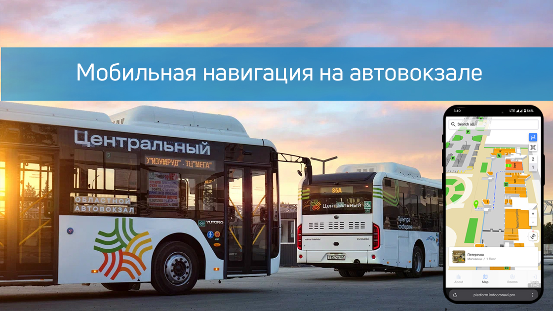
The Indoors Navigation team has implemented smart navigation in the Central Bus Station of Rostov-on-Don!
Now passengers can easily find their bus or the desired area using:
✅ A mobile application with a 3D map and turn-by-turn navigation
✅ Interactive terminals (infomats)
✅ QR codes (works without installing the app)
✅ Augmented reality (AR pointers through the camera) The system is powered by 400 BLE sensors, providing accurate positioning.
Benefit for passengers:
➜ Saving time
➜ Ease of use
➜ Accessibility without downloading the app
Benefits for the bus station:
📊 Movement analytics (heat maps, route history)
📉 Reducing staff workload
🔄 Improving the quality of service
Modern technology is for everyone's comfort! Indoors Navigation is not just a navigation system, but a powerful building management platform that helps make your business more transparent, secure, and efficient.
Discover the future of geographic information systems with the Indoors Navigation Platform. 🌐
📍 What will you see?
• The digital twin of the enterprise in action
• Indoor geolocation services
• Interactive navigation with QR codes and AR
🛠 How to integrate it?
• We create personalized solutions for each client. Contact us for a demo.
👇 Subscribe and keep up to date with innovations! 👇
Learn more about new developments and the geographic information system of the Indoors Navigation Platform: https://indoorsnavi.pro/
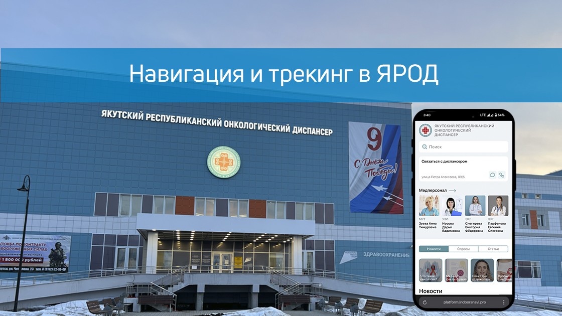
The company Indoors Navigation has implemented a patient navigation and tracking system in the Yakutsk Regional Oncological Dispensary (YAROD), solving the key problems of the medical facility.:
The difficulty of orientation in the hospital building
Search for doctors' offices and medical equipment
Control of patient movements
Implemented solutions:
Hardware search for medical staff
Accurate 3D map buildings with furniture detailing
The mobile app navigator with: — Поиском кабинетов и врачей — Маршрутизацией и позиционированием (+ AR-режимы) — 360° панорамами помещений
QR navigation for guests without an app
Tracking system patients through BLE Navitag bracelets
Implementation results:
✔ Reducing the search time for cabinets ✔ Simplification of patient monitoring ✔ Optimization of visitor flows ✔ Reducing the burden on staff
The technology is available:
In the mobile app
On interactive terminals
Via the web version
To learn more about new developments and the geographic information system of the Indoors Navigation Platform for medical institutions, follow the link: https://indoorsnavi.pro/
👇 Subscribe and keep up to date with innovations! 👇
Managing large facilities such as office buildings, warehouses, production facilities or shopping malls involves a number of difficulties. One of the key tasks is to control the movement of employees and material assets. The lack of effective monitoring can lead to work disruptions, discipline violations, and in some cases, damage or theft of property.
The company Indoors Navigation offers a modern solution that minimizes these risks and improves the efficiency of facility management.
Problems faced by building administrators:
1. Lack of control over staff movement. Employees may be in the wrong places or spend their working hours inefficiently. A violation of discipline can lead to a decrease in productivity.
2. Risks associated with tangible assets: The lack of tracking of the movement of equipment or goods increases the likelihood of damage or theft. Difficulties in finding assets inside the building.
3. Inefficient use of resources: The inability to optimize work processes due to the lack of data on the movements of employees and equipment.
A solution from Indoors Navigation
The Indoors Navigation platform is a universal building management tool that allows you to solve these problems.
How does it work?
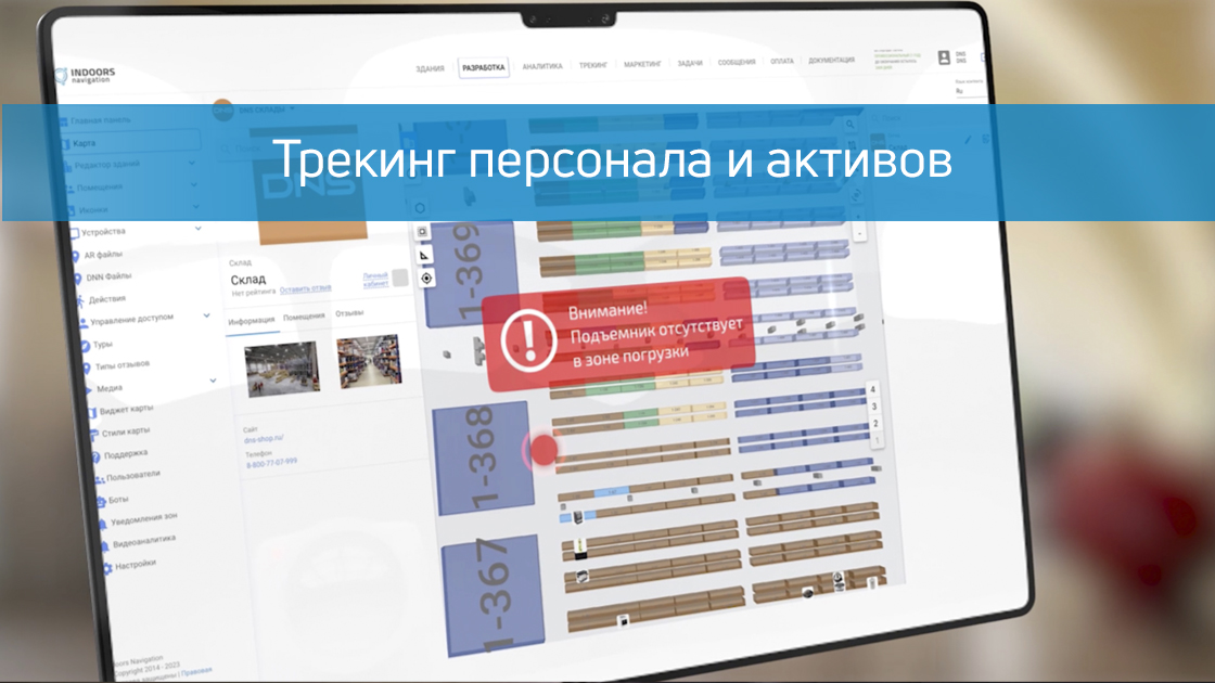
For employees: A special mobile application is installed, or badges or bracelets with BLE (Bluetooth Low Energy) technology are issued. Каждый сотрудник становится «видимым» в системе, что позволяет отслеживать его местоположение в режиме реального времени.
For tangible assets: Electronic BLE tags are attached to equipment, goods, or other valuables. The administrator can track their movement inside the building and on the territory.
For the administrator: Information about the location of employees and assets is displayed in real time. The ability to control the time employees stay in certain areas. Receiving notifications about unauthorized movements or violations.
The integration of geomarketing with the Indoors Navigation platform allows businesses not only to receive data, but also to optimize processes based on it.
Advantages of the Indoors Navigation Platform:
Контроль дисциплины — администратор может отслеживать, где находятся сотрудники и как они используют рабочее время, а это помогает предотвратить нарушения и повысить производительность.
Защита активов — система позволяет минимизировать риски хищения или порчи имущества благодаря постоянному мониторингу перемещения материальных ценностей.
Оптимизация процессов — данные о перемещениях сотрудников и активов помогают выявить узкие места в рабочих процессах и повысить общую эффективность.
Универсальность — платформа подходит для различных типов зданий: офисов, складов, производственных помещений, торговых центров и других объектов.
The Indoors Navigation platform is not only a tool for tracking movements. It is a comprehensive building management solution that allows:
Monitor operational systems and services.
Optimize production processes.
To increase the safety and transparency of work at the facility.
The Indoors Navigation platform is a reliable assistant for building administrators, which allows them to take control of the movement of personnel and assets, increase discipline and optimize work processes.
Modern business is built on data. Companies that understand their customers and their needs are always one step ahead of the competition. In large shopping malls, sports stadiums, office complexes, and transportation hubs, understanding how and where people are moving becomes a key success factor.
Geomarketing is a technology that combines data on visitors' movements inside buildings with analytics tools. The goal? Create an accurate and detailed picture of customer behavior.
Indoors Navigation offers geomarketing solutions that help businesses answer their most important questions.:
Where is the largest concentration of visitors in the building?
What routes do customers choose?
How long do they stay in certain areas?
Which areas of the building are less in demand and require improvement?
How it works: Geolocation and digital twin technologies
Our solutions are based on modern technologies of digital building doubles and positioning systems. The platform is based on several key components:
The digital twin of the building. This is an exact virtual copy of the space where the layout of premises, shops, crosswalks, as well as other infrastructure elements are displayed.
Sensors and Wi-Fi tracking. Movement data is collected through sensors, mobile apps, and Wi-Fi access points. We record the movement of visitors and build anonymized routes.
An analytical platform. The data is processed and transformed into user-friendly reports and visualizations. For example, heat maps, attendance schedules, and reports on customer location.
The integration of geomarketing with the Indoors Navigation platform allows businesses not only to receive data, but also to optimize processes based on it.
Main features and advantages
Тепловые карты перемещений
With the help of heat maps, you can see where visitors spend the most time, and which areas of the building are practically unused. It is an ideal tool for:
Optimization of the location of shops and kiosks.
Planning of advertising campaigns and navigation signs.
Improving the logistics of flows inside the building.
Route analytics
What routes do visitors choose? How do they get to their destination? Route analysis helps you understand customer behavior and improve navigation. For example:
If most visitors avoid a certain corridor, it is worth improving its lighting or signage.
Routes to popular stores can be used to place advertising stands.
User segmentation
With the help of analytics, you can divide the audience into segments by gender, age, time of visits, and other parameters. This allows you to:
Create personalized advertising offers.
Analyze the target audience in terms of specific locations.
Evaluation of the effectiveness of advertising and promotions
Have you launched a new advertising campaign or held an event? Geomarketing allows you to accurately measure performance:
How has the flow of visitors changed?
Has the time spent in the desired area increased?
How many people saw the ad and clicked through to the target store?
Zone planning and optimization
Geoanalytics helps to design the building space correctly:
Increase the traffic capacity of poorly loaded areas.
Optimize the rental of premises.
Expand popular areas with high concentrations of people.
Who is this solution for?
Our solutions are suitable for a wide range of industries and facilities.:
Shopping malls and retail. Increasing the flow of customers, optimizing rentals, and accurate advertising targeting.
Transport hubs. Improving passenger traffic, navigation planning, and managing advertising surfaces.
Sports arenas and stadiums. Analyzing fan routes, optimizing points of sale and food courts.
Office spaces and business centers. Management of internal processes and analysis of employee movements.
Museums and cultural sites. Planning the routes of visitors and improving the attendance of exhibitions.
Cases: how does Indoors Navigation already help businesses
Case number 1: Shopping Mall After the introduction of Indoors Navigation geoanalytics, one of the major shopping malls optimized its advertising campaigns and increased revenue by 15%. Heat maps showed where to place ads and improve navigation.
Case number 2: Railway station Several "bottlenecks" were identified at the station, which prevented passengers from quickly finding the right platforms. Thanks to analytics and improved navigation, route travel time has been reduced by 20%.
Case number 3: Museum The analysis showed that some halls of the museum remained almost unnoticed. Thanks to the updated signage and navigation, the attendance of less popular expositions increased by 2 times.
Geomarketing is not just about analytics. It is a tool for understanding the customer, improving the quality of service and increasing profits. Find out how Indoor Navigation can help your business today!
Learn more about how the Indoors Navigation Platform can transform your facility and offer your visitors a new level of comfort and safety. Contact us for a consultation and demonstration of the platform's capabilities.
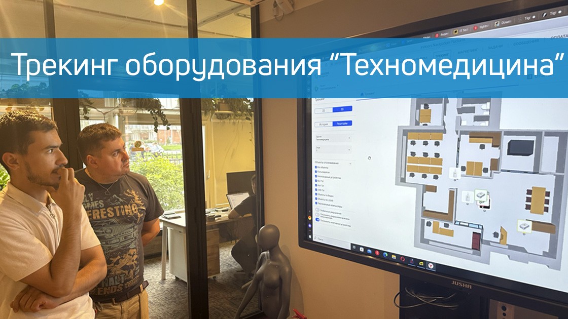
The Indoors Navigation team has deployed a system for tracking the movement of personnel and medical equipment in the showroom of the official distributor of professional medical equipment, Techno Medicine Company.
В нескольких помещениях было установлено оборудование — приемники для считывания сигнала от меток (NaviTagThe project used Ultra-WideBand technology, which made it possible to achieve high positioning accuracy of up to 0.5 meters.
Now, in real-time mode, companies can observe how the equipment is moving, view the history of routes and conduct demonstrations of new technologies.
For more information about the company and its products, you can visit our website.: https://indoorsnavi.pro/
Discover the future of geographic information systems with the Indoors Navigation Platform. 🌐
📍 What will you see?
• The digital twin of the enterprise in action
• Indoor geolocation services
• Interactive navigation with QR codes and AR
🛠 How to integrate it?
• We create personalized solutions for each client. Contact us for a demo.
👇 Subscribe and keep up to date with innovations! 👇
Learn more about new developments and the geographic information system of the Indoors Navigation Platform: https://indoorsnavi.pro/
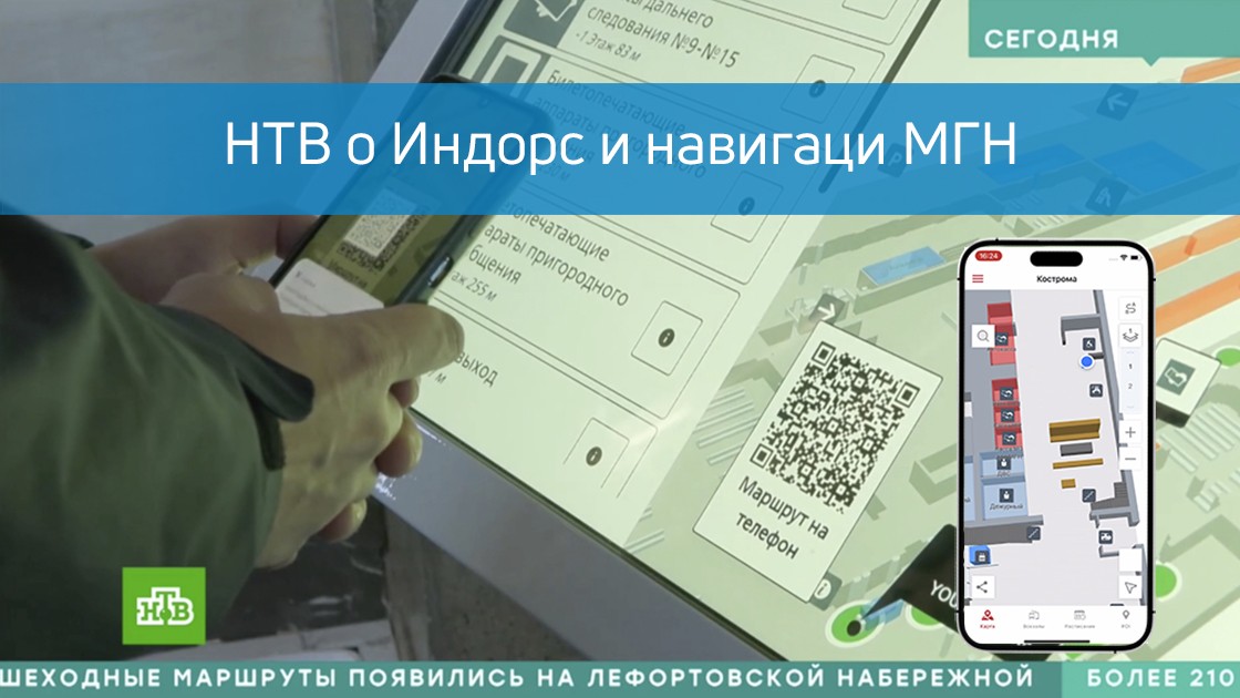
The NTV channel's news program Today featured a story about the Indoors Navigation solution for people with disabilities at railway stations.
This video shows how our navigation system helps people with limited mobility (MH) easily navigate complex transport hubs, find the right platforms, ticket offices and exits.
How modern technologies make train stations more accessible and travel safer and more comfortable for all passengers!"
Единая информационная среда для управления зданиями и активами — геоинформационная система (ГИС) на основе цифрового двойника объекта и геолокационных сервисов внутри помещений Indoors Navigation Platform (INP).
Learn more on the website www.indoorsnavi.pro
Discover the future of geographic information systems with the Indoors Navigation Platform. 🌐
📍 What will you see?
• The digital twin of the enterprise in action
• Indoor geolocation services
• Interactive navigation with QR codes and AR
🛠 How to integrate it?
• We create personalized solutions for each client. Contact us for a demo
👇 Subscribe and keep up to date with innovations! 👇
Learn more about solutions based on the geographic information system of the Indoors Navigation Platform
For more information about navigation in public places, follow the link: https://indoorsnavi.pro/
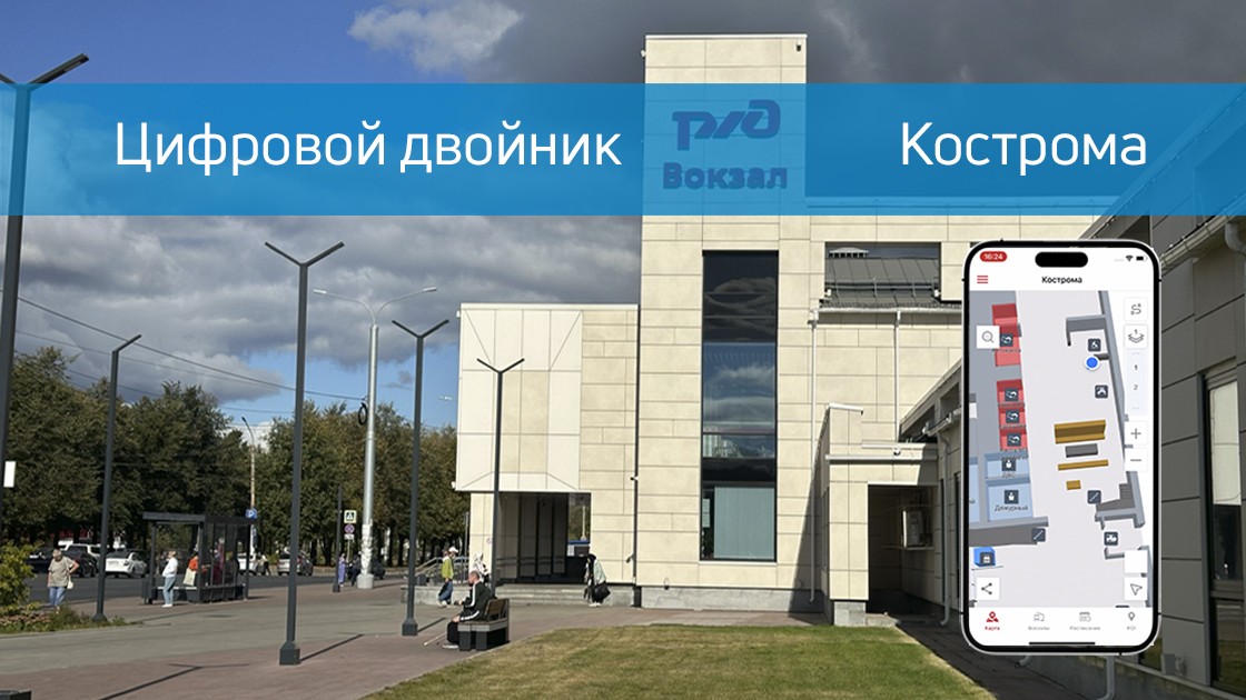
In September 2024, Indoors Navigation successfully completed a project to digitize and implement a passenger navigation system on Kostroma railway station. This project has become part of the overall digitalization program of Russian railway facilities aimed at improving passenger convenience and safety.
The main goal of the project was to create a convenient and intuitive navigation system that would allow passengers to quickly find the necessary facilities at the station, such as platforms, ticket offices, recreation areas and other important infrastructure facilities.
The project also included the digitization of the station with the creation of a digital twin, which allows both passengers and the administration to effectively interact with data about the station in real time.
The Indoors Navigation project in Kostroma has shown that the introduction of modern navigation systems at transport facilities can significantly improve the quality of passenger service. The system allows you to optimize the management of the facility, improve the organization of passenger flows and provide convenient navigation tools.
Indoors Navigation Platform — It is a universal solution for transportation facilities that will help you improve navigation and management. Contact us for a consultation and find out how our system can improve your train station or transport hub.
Discover the future of geographic information systems with the Indoors Navigation Platform. 🌐
📍 What will you see?
• The digital twin of the enterprise in action
• Indoor geolocation services
• Interactive navigation with QR codes and AR
🛠 How to integrate it?
• We create personalized solutions for each client. Contact us for a demo.
👇 Subscribe and keep up to date with innovations! 👇
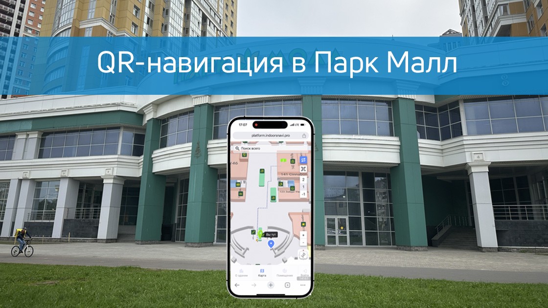
In St. Petersburg, we have launched interactive navigation in the Park Mall shopping and entertainment complex. The visitor does not need to install a mobile application to get acquainted with the map of the shopping mall and the location of the shops, or to set a route to the restaurant of interest.
It is enough for the user to scan the nearest QR code on the wall and a map with a marked location will open in the phone browser. Having found the desired point of interest through the search, the user will get the shortest route to it.
QR-навигация в торговых центрах — один из наиболее доступных и удобных способов помочь посетителя сориентироваться, понять свое местоположение и найти нужный магазин в ТЦ.
For more information about the company and its products, you can visit our website.: https://indoorsnavi.pro/
Discover the future of geographic information systems with the Indoors Navigation Platform. 🌐
📍 What will you see?
• The digital twin of the enterprise in action
• Indoor geolocation services
• Interactive navigation with QR codes and AR
🛠 How to integrate it?
• We create personalized solutions for each client. Contact us for a demo.
👇 Subscribe and keep up to date with innovations! 👇
Learn more about new developments and the geographic information system of the Indoors Navigation Platform: https://indoorsnavi.pro/
Этот веб-сайт использует файлы cookie для улучшения вашего опыта во время навигации по веб-сайту. Из них файлы cookie, которые классифицируются как необходимые, хранятся в вашем браузере, поскольку они необходимы для работы основных функций веб-сайта. Мы также используем сторонние файлы cookie, которые помогают нам анализировать и понимать, как вы используете этот веб-сайт. Эти файлы cookie будут храниться в вашем браузере только с вашего согласия. У вас также есть возможность отказаться от этих файлов cookie. Но отказ от некоторых из этих файлов cookie может повлиять на ваш опыт просмотра.
Необходимые файлы cookie абсолютно необходимы для правильной работы веб-сайта. В эту категорию входят только файлы cookie, обеспечивающие базовые функции и функции безопасности веб-сайта. Эти файлы cookie не хранят никакой личной информации.
Любые файлы cookie, которые могут не быть особенно необходимыми для функционирования веб-сайта и используются специально для сбора персональных данных пользователей с помощью аналитики, рекламы и другого встроенного содержимого, называются необязательными файлами cookie. Перед запуском этих файлов cookie на вашем веб-сайте обязательно получить согласие пользователя.