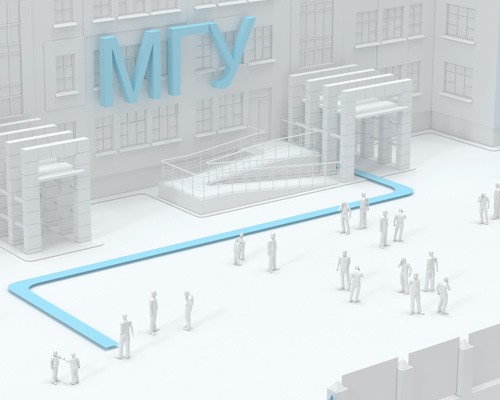
Навигация в университетах
Мобильное приложение позволяет получать информацию о задании, расписании занятий, и других важных событиях, а также связываться с преподавателями и администрацией.
Современная навигация в учебных заведениях включает использование инновационных технологий для обеспечения удобства и безопасности обучающихся и сотрудников.
В первую очередь это системы позиционирования в помещениях, которые помогают найти нужную аудиторию или кабинет, а также обеспечивают эвакуацию в случае пожара или другой угрозы.
Интерактивные карты здания или кампуса, которые позволяют быстро и легко ориентироваться в пространстве и находить нужные объекты, такие как библиотеки, столовые, спортивные залы и прочее.
Учебные заведения используют системы трекинга присутствия студентов на занятиях, которые связаны с системой позиционирования INP. Это позволяет отслеживать посещаемость и давать студентам обратную связь о качестве их учебы.

Цифровизация учебных заведений – это процесс внедрения современных технологий в учебный процесс, который включает в себя использование цифровых инструментов и ресурсов, таких как электронные учебники, интерактивные доски, онлайн-курсы и другие.
Улучшение организации пространства внутри учебного заведения за счет системы позиционирования и indoor-навигации позволяют определить местоположение студентов и преподавателей, что помогает в создании более эффективных расписаний, уменьшении проблем с поиском аудиторий и мест с проведением занятий.
Цифровизация школ и университетов с использованием систем навигации в помещениях имеет множество преимуществ и может значительно улучшить процесс обучения и безопасность на территории учебного заведения.
Преимущества для учебного заведения:
Управление потоками посетителей:
Системы позиционирования могут помочь в определении местоположения студентов и персонала внутри здания, что может быть полезно для управления потоком людей и повышения безопасности
Безопасность:
В случае возникновения чрезвычайных ситуаций, например, пожара или эвакуации, системы позиционирования могут помочь в быстром и эффективном определении местоположения студентов и персонала
Навигация и картография:
Системы indoor навигации могут использоваться для создания интерактивных карт здания университета. С помощью мобильных приложений и карт учебного заведения студенты могут быстро и легко найти нужную аудиторию, кабинет преподавателя или библиотеку, что экономит их время и снижает уровень стресса
Родительский контроль:
Системы позиционирования могут быть полезны для родителей, которые хотят отслеживать местоположение своих детей на территории учебного заведения. С помощью специальных приложений родители могут получать уведомления о перемещении своих детей внутри учебного заведения и быть уверены в их безопасности
Улучшение пользовательского опыта:
Системы позиционирования в помещениях университетов могут помочь улучшить пользовательский опыт студентов и персонала, обеспечивая более удобное перемещение и более эффективное использование ресурсов
Управление имуществом и ресурсами:
Решения отслеживанию перемещений в помещениях могут использоваться для управления имуществом в университете, таким как книги в библиотеке или оборудование в лабораториях, позволяя более эффективно контролировать их использование. Мониторинг энергопотребления в университете, помогает оптимизировать расходы на электроэнергию и воду
Новый канал связи с посетителями, сотрудниками и и арендаторами
Быстрое информирование о изменениях на территории тц с привязкой к геопозиции
Полезные развлекательные сервисы на основе дополненной реальности и AR навигация
Решения для людей с ограниченными возможностями. Аудиогиды

Забота о студентах
Цифровизация и внедрение системы позиционирования в учебных заведениях помогает создать более комфортные условия для студентов. Они могут легко ориентироваться в пространстве университета, быстрее находить нужные аудитории и другие объекты, а также избегать потери времени на поиск необходимых мест.
Кроме того, цифровые технологии позволяют улучшить качество образования, облегчив процесс обучения и повысив эффективность учебного процесса.
Что получает посетитель учебного заведения:
- Оптимизация маршрута: Система навигации поможет посетителю быстрее и проще найти нужное место в здании, что сократит время на поиск и снизит уровень стресса.
- Удобство: Посетитель сможет легко найти нужный кабинет, аудиторию, библиотеку, столовую или другие объекты учебного заведения. Это сделает посещение учебного заведения более комфортным и приятным.
- Экономия времени: Благодаря системе навигации посетитель учебного заведения может быстро найти необходимое место, что позволит ему лучше использовать свое время и не опаздывать на занятия.
- Улучшение безопасности: Система навигации может помочь посетителю учебного заведения быстро найти выход в случае возникновения аварийной ситуации, что повысит безопасность всех находящихся в здании.
- Повышение уровня сервиса: Внедрение системы навигации в учебное заведение может повысить уровень сервиса и удовлетворенности посетителей, что может привести к росту репутации учебного заведения и увеличению числа студентов.

Цифровизация учебных заведений
Цифровизация учебных заведений с использованием систем навигации — это шаг вперед в области образования. Внедрение современных технологий трекинга в помещениях, помогает создавать комфортные условия для студентов и улучшает процесс обучения.
Что получает администрация учебного заведения:
- Улучшенный контроль и управление. Система навигации позволяет администрации учебного заведения отслеживать перемещения студентов, преподавателей и другого персонала в реальном времени. Это может помочь эффективнее контролировать работу персонала и управлять процессами в учебном заведении.
- Повышение безопасности. Система навигации может помочь обеспечить безопасность студентов и персонала, особенно в крупных учебных заведениях. Она может помочь определить местоположение человека в случае чрезвычайной ситуации, такой как пожар или другая угроза безопасности, и быстро организовать эвакуацию.
- Улучшенный сервис для посетителей. Система навигации может помочь посетителям учебного заведения легче ориентироваться в его пространствах и находить нужные им объекты (аудитории, кабинеты, библиотеку, столовую и т.д.). Это может улучшить удобство посещения учебного заведения и повысить уровень его сервиса.
- Улучшенное управление ресурсами. Система навигации может помочь администрации учебного заведения оптимизировать использование своих ресурсов, таких как аудитории, лаборатории и т.д. Это может помочь улучшить планирование занятий, избежать пересечений в расписании и повысить эффективность.
- Улучшенное взаимодействие со студентами. Система навигации может помочь администрации учебного заведения установить более эффективное взаимодействие со студентами, например, путем отправки сообщений с информацией о предстоящих мероприятиях, изменениях в расписании и других важных событиях. Это может повысить уровень участия студентов в жизни учебного заведения.
Актуальность внедрения ГИС Indoors Navigation Platform
Индорс Навигейшн предоставляет новые современные сервисы, благодаря которым институты и университеты смогут максимально эффективно работать с оффлайн и онлайн аудиторией среди студентов.
Тематические публикации в нашем блоге

Навигация в школах и учебных заведениях
В рамках реализации инициатив Национальной технологической инициативы (НТИ), проект «Аэронет» Современные образовательные учреждения сталкиваются с многочисленными вызовами, связанными с безопасностью, управлением процессами и повышением эффективности.

Что такое позиционирование в помещениях? Обзор технологий
Позиционирование в помещениях — это технология, которая позволяет определить местоположение человека внутри здания или помещения с помощью различных сенсоров и систем. Эта технология может быть использована в различных облас…
Частые вопросы о внедрении навигации в ВУЗ
Что такое ГИС для учебных заведений и университетов и зачем она нужна?
Геоинформационная система (ГИС) для учебных заведений — это инструмент, который помогает управлять пространством кампуса, отслеживать потоки студентов и сотрудников, обеспечивать удобную навигацию по территории и повышать безопасность. ГИС делает ориентирование на территории университета проще и эффективнее, а также помогает администраторам управлять ресурсами.
Какие преимущества дает внедрение ГИС в учебных заведениях?
ГИС улучшает навигацию для студентов, сотрудников и посетителей, повышает уровень безопасности, помогает оптимально управлять кампусом, поддерживает планирование мероприятий и повышает удобство пребывания на территории университета.
Как студенты и сотрудники могут использовать ГИС в университете?
ГИС предоставляет интерактивные карты через мобильные приложения и информационные терминалы, помогая пользователям находить нужные здания, аудитории, библиотеки, кафе, парковки и другие объекты кампуса.
Какие данные собирает ГИС в университете?
ГИС может собирать данные о посещаемости зданий, передвижении студентов и сотрудников, загруженности зон кампуса и использовать эту информацию для улучшения управления ресурсами и инфраструктурой.
Насколько сложно управлять ГИС после ее установки?
Современные ГИС-платформы имеют удобный интерфейс и обычно включают инструменты для управления данными, обновления карт и мониторинга, что делает систему удобной для использования даже после установки.
Как ГИС помогает в организации мероприятий на кампусе?
ГИС предоставляет информацию о наиболее удобных маршрутах, зонах для проведения мероприятий, доступности парковочных мест и потоках людей, помогая администраторам эффективно организовать события и минимизировать скопление людей.
Как внедрение ГИС улучшает общее впечатление студентов и посетителей?
ГИС облегчает навигацию, помогает быстро находить нужные объекты и улучшает общий опыт пребывания на кампусе, создавая комфортные условия для учебы и работы.
