Navigation in parking lots
Digitalization of parking spaces is a necessary minimum at the current pace of urban development and represents the process of introducing modern solutions to optimize the management and use of parking areas.
Modern parking navigation solutions include technologies aimed at simplifying the process of finding a parking space and improving the overall efficiency of parking systems, increasing accessibility for all types of users.
Digitalization of underground parking is aimed at creating an intelligent and convenient environment for drivers and residents, where each stage of parking is maximally adapted to their needs: remote booking, payment, and quick search for a place in a communal parking lot.
Improving the comfort for drivers and pedestrians, increasing profitability and reducing costs during parking operation is achieved by the introduction of GIS INP. ГИС INP.
How parking navigation works

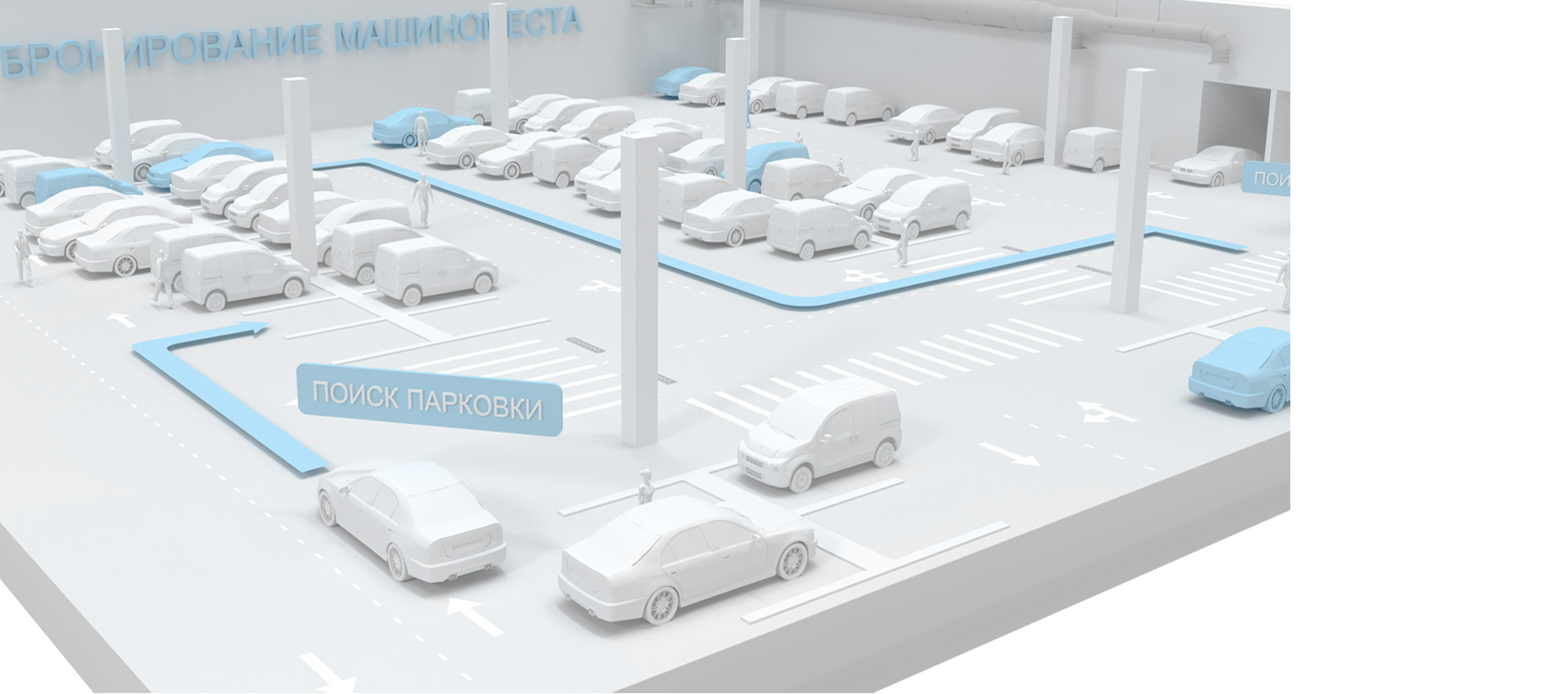
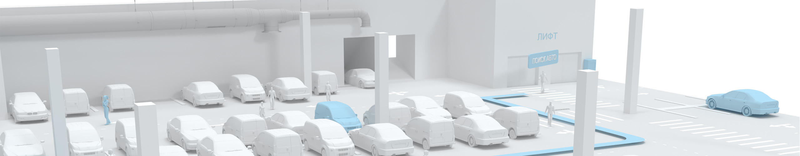
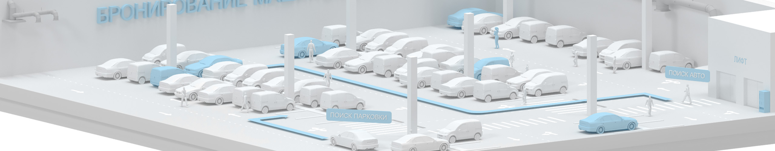
Modern digital parking navigation is carried out through a website, an infomat or a mobile application, which is part of a geographic information system based on the digital twin of the parking spaces, the Indoors Navigation Platform®. инфомат или мобильное приложение, являющееся частью геоинформационной системы на основе цифрового двойника парковки Indoors Navigation Platform®.

The mobile application has navigation functionality with tracking the position of the user, both pedestrian and motorist, throughout the open or underground parking area due to a digital 3D map administered via a web-based control panel.
The parking floor and the user's position on it are determined automatically by the mobile application due to bluetooth signals from INB v1.2 positional sensors or analogues installed on the site.

The user is guided along the route as in the navigator, and also gets the opportunity to view the description and photo of the parking space, book it if it is free and the application is approved by the administrator or the owner. Notifications about the start and end of the booking are sent to the mobile application.
The user of the mobile application can also use augmented reality (AR) mode to navigate the route in the parking lot and display a digital map of the parking lot.

If the user does not have a mobile application, he can scan the QR code on the territory and download an interactive parking map in the mobile phone browser indicating the location where he is located. Set a route to a point of interest, view the description and photos of the parking space, and book it.

Using the INP built into the platform® messenger, the user can contact the administrator, send a request to the technical support channel or other users.
If the parking space is occupied by another car, or the lighting is not working there, the user can send a corresponding complaint/request from the mobile application linked to the location.

Registered users in the INP platform can use the parking reservation service.® platform and those who have logged into their personal account using their username and password in the mobile application or smartphone browser.
In your personal account, enter your full name, photo, e-mail, phone number, description, make and number of the car, and other data.
Automatic determination of whether a parking space is occupied or not is carried out based on the geo-location data of the user whose car is tied to the parking space, or by integrating the API of parking cameras and sensors.

A digital parking map is created in the INP platform's web dashboard, user routes, entrances, exits, elevators, stairs, and other points of interest (POIs) are set, and parking reservation modes are configured.

The administrator processes, confirms and rejects applications for rental of parking spaces from users of the mobile application in a single web-based control panel of the INP® platform.®It can add and remove parking spaces, adjust the availability of reservations, and see data from the user's personal account.

User movement statistics are collected in the Analytics section of the web dashboard, visualized as graphs and heat maps, and uploaded as reports.

A mobile application based on the Interiors SDK can manage the underground parking equipment when integrated via the API.
Due to the video analytics module of the INP® platform® and integration into the ACS, it is possible to control gates and barriers when recognizing the user's face or car license plate.
Advantages for parking:

The digital twin of parking
A virtual representation of the parking area with all engineering communications, the ability to control equipment and display in real time up-to-date information about the availability of parking spaces

Interactive map of the parking area
GIS INP allows you to create a digital map of the parking area with an accurate indication of the location of each parking space and their parameters. Provides user guidance along the route as in the navigator to the selected parking space, elevator or exit. Integration with IOT

Monitoring of parking personnel and equipment
The INP tracking module is used to increase labor efficiency and optimize the working hours of parking staff, as well as monitor their performance of their duties. Security guards, cleaners, and engineers will spend more time doing their jobs and less time smoking, knowing that management has information about where they are.

Booking and paying for parking
The functionality of booking parking spaces and paying for them in the GIS Interiors Navigation Platform allows drivers to pre-schedule their visit and avoid inconveniences when searching for a parking space after the visit.

Statistical data and analytics of parking movements
GIS collects data on the use of parking spaces, which allows you to analyze trends, predict congestion, create reports and heat maps to optimize parking management. Visual routes of movement of visitors and staff in different time periods.

Client orientation
The modern standard of service for drivers and owners of parking spaces allows you to create maximum comfort when visiting a parking lot in a residential complex, shopping mall or office center.
Simplify your navigation by using a digital map and navigator on your personal mobile devices.

What the user gets:
- A map of the entire parking lot in your mobile phone with visualization of the parking area scheme.
- Optimal routes to free parking spaces, elevators and exits.
- Book parking spaces in advance, ensuring the availability of space upon arrival.
- A quick search for specialized areas, such as places for the disabled or charging stations for electric vehicles.
- The opportunity to rent out your parking space and earn additional income.
- Communication channel with the administration, targeted chats and reviews.
- Gamification of the visiting process through the use of augmented reality. AR navigation in the parking lot and virtual game scenarios.

Digitalization
Digitalization includes the introduction of automated parking management systems that can regulate access to parking spaces, optimize space use, and collect analytical data.
INP successfully helps to manage the internal processes of any parking space.
Improve the control of your parking lot's employees, allowing you to distribute workload and resources more efficiently.

What does the parking administration get?:
- A detailed map of the parking space, indicating the status of each location.
- Statistical data and analytical reports in different time periods.
- The ability to manage workflows online. Tracking the movements of employees and equipment on the map.
- Optimizing the use of parking space, taking into account the popularity of various zones, days, and hours.
- Automation of control and maintenance processes, integration with the ticket system and payment.
- A new user feedback channel on the same platform.
- Increased security in the parking lot and visual information about the events taking place on the territory.
- Reduce maintenance costs and increase the economic efficiency of parking.

Effectiveness and relevance
The introduction of the INP geographic information system, the use of positioning and tracking tools, will help increase the efficiency of the entire parking lot by 30%, increase the rental yield of parking spaces by 25%, improve the quality of visitor service by 20%, and asset safety by 15% (inventory and equipment).
Thematic publications on our blog
Intelligent Parking System – how it works
Car parking navigation solutions work for both indoor and outdoor parking systems and can be created to achieve optimal performance. Thus, the use of navigation…

Booking meeting rooms, work spaces and parking spaces in the modern world
In today's world, where every minute counts, efficient use of office space and resources is becoming a key aspect of a successful business. Modern booking systems for meeting rooms, workstations…
Frequently Asked Questions about parking navigation with the Indoors Navigation Platform (INP)
What is parking digitalization using a geographic information system?
Digitalization of parking with a geographic information system (GIS) is the introduction of technologies to optimize the use of parking space and improve parking navigation.
What is modern parking navigation?
Modern parking navigation offers the use of technologies such as geographic information systems (GIS), sensors, cameras and mobile applications to optimize the search and management of parking spaces.
What are the advantages of modern navigation and GIS in parking?
The advantages include the opportunity to generate additional income, optimize the use of parking space, reduce the time needed to find a place, increase security, ease of use, and support various services for drivers and pedestrians.
What are the costs of implementing a digital GIS twin in the parking lot?
The cost varies depending on the size of the parking lot and the technology used. The main part of the expenses is equipment, software, integration with third-party systems and commissioning.
Can I book a parking space in advance using INP?
Yes, our indoor navigation system allows drivers to book parking spaces in advance via mobile apps or the web widget of the Indoors Navigation Platform.
How does the system notify you about the availability of seats?
The INP platform can use mobile notifications and information boards (infomats) to indicate the availability of free or occupied parking spaces.
How do drivers interact with the GIS system in the parking lot?
Drivers and other users can use mobile applications to find places, book and pay for parking, as well as receive information about the condition of the parking space.
What are the possibilities for integrating existing parking engineering systems with the INP platform?
Our interactive map platform has been developed taking into account the possibility of integration with existing engineering parking management systems and transport infrastructure through an open API.
Do I need to download a special application to use the INP system?
Not obligatory. In the browser, you can use the client solution without installing third-party applications, just scan the QR code or download an interactive map with the location of parking spaces.
To use the ability to navigate a route in real time and track movements, you need to install a mobile application that can be found in the appropriate stores for your device or integrated into a ready-made application using the Interiors SDK. Detailed documentation is available in the INP platform control panel.
What is the accuracy of the Indoor Navigation Platform's indoor positioning system?
The accuracy of INP indoor positioning may depend on the type of equipment used and the chosen technology, and may vary from 0.5 meters to 3 meters. On the street, the accuracy is determined by the quality of GPS signal reception and is about 10 meters.
Where is all user data stored and how can it be used?
The user data collected using the indoor positioning system can only be used to optimize routes and better resource planning. They are stored in encrypted form on the administration's servers.