
As part of the implementation of the initiatives of the National Technology Initiative (NTI), the Aeronet project occupies a special place aimed at developing advanced technologies in the field of unmanned aerial vehicles, navigation systems and geoinformation solutions. As a leading developer of indoor navigation and asset management solutions, Indoors Navigation makes a significant contribution to achieving Aeronet's goals. Our innovative developments, in particular the Indoors Navigation Platform (INP), not only meet the requirements of the roadmap, but also open up new perspectives for the use of unmanned vehicles in enclosed spaces.
Contribution of Indoors Navigation to the realization of Aeronet's goals
The Aeronet project is aimed at creating integrated systems that ensure high accuracy of navigation and control of unmanned aerial vehicles (UAVs). One of the key tasks is to develop technologies that make it possible to effectively use UAVs not only in open spaces, but also in enclosed spaces. It is in this aspect that the Indoor Navigation solutions play an important role.
The Indoors Navigation Platform, based on the use of digital object doubles and advanced geolocation services, provides high accuracy of positioning and navigation inside buildings. This platform allows the drone to move safely and precisely indoors, providing unprecedented opportunities for automation of various processes, including logistics, inspections and monitoring.
The possibilities of using the Indoors Navigation Platform for UAVs
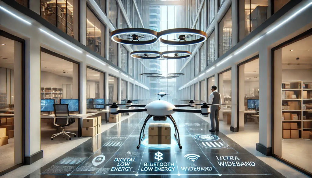
INP is a comprehensive geographic information system capable of operating in confined spaces where traditional navigation methods such as GPS are losing their effectiveness. The platform uses BLE (Bluetooth Low Energy), UWB (Ultra-Wideband) technologies, and integrates video analytics and machine learning algorithms, which ensures high accuracy and reliability of positioning drones in all conditions.
For example, in large logistics centers or industrial enterprises where it is necessary to automate the movement of goods or monitor the state of infrastructure, the use of unmanned vehicles integrated with the Indoors Navigation Platform can significantly increase efficiency and reduce costs. The platform ensures accurate route tracking, obstacle avoidance and timely completion of tasks, which is especially important in conditions of limited space and high density of objects.

Digital twin as a basis for indoor navigation
One of the key elements of the Indoors Navigation Platform is the use of digital twin technology. A digital twin is a virtual copy of a physical object or infrastructure that is synchronized with the real world and updated in real time. This allows unmanned vehicles to navigate in space with high accuracy, using data on the current state of the object, its characteristics and changes.
The digital twin not only provides indoor navigation, but also provides data for process analysis and optimization. For example, in the case of infrastructure monitoring, drones can use digital twin data to detect problem areas, plan inspection routes, and automatically send reports if deviations from the norm are detected. This is especially important in the context of Aeronet's objectives aimed at improving the safety and efficiency of UAV use.
Synergy with the Aeronet roadmap
One of the key aspects of the Aeronet project is the creation of an ecosystem that integrates various technologies and solutions. The Indoors Navigation Platform fully meets these requirements, offering flexibility in configuration and integration with existing control and navigation systems.
Our platform supports integration with BIM (Building Information Modeling), construction management Systems (CMS) and ERP systems, which allows you to create a single information space for managing facilities and assets. In addition, the open API of the Indoors Navigation Platform provides the ability to integrate with various UAV control systems, which makes our platform a universal solution for navigation and control tasks within the Aeronet implementation.
Application of the Indoors Navigation Platform in smart cities and transport hubs
As part of the Aeronet implementation, special attention is being paid to the development of technologies for smart cities and transport hubs. The Indoors Navigation Platform provides all the necessary tools to create modern navigation systems in such conditions. The platform allows you to manage the flow of people and vehicles, monitor the state of the infrastructure and ensure safety at facilities.
For example, at airports and train stations, the Indoors Navigation Platform can be used to automatically monitor the movement of UAVs, ensuring effective inspection and monitoring tasks. This makes it possible to significantly reduce infrastructure maintenance costs and increase security, which is consistent with the objectives of the Aeronet roadmap.
And what happened in the end
The Indoors Navigation Platform opens up new opportunities for the implementation of the tasks of the Aeronet NTI roadmap. Our solutions ensure high accuracy and reliability of indoor navigation, which is especially important for the use of unmanned aerial vehicles in enclosed spaces. The implementation of our platform allows us to significantly increase the efficiency of using UAVs, reduce costs and ensure safety at facilities.
The company Indoors Navigation continues to actively develop its technologies, supporting NTI initiatives and offering innovative solutions for smart cities and transport hubs. Our products have already proven their effectiveness on a number of major projects, and we are confident that their potential will be in demand as part of the implementation of Aeronet and other initiatives aimed at Russia's digital transformation.
Learn more about the application of Indoors Navigation solutions for positioning on the construction site on our on the website .