BLE navigation
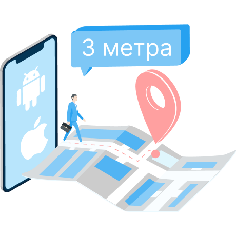
One of the most effective and affordable solutions for indoor navigation is BLE navigation technology and iBeacon beacons. The positioning accuracy is up to 3 meters.
Shopping malls, airports, hospitals, museums, and office buildings all require an accurate, convenient, and accessible way to navigate using mobile devices.
BLE (Bluetooth Low Energy) is an energy efficient version of Bluetooth technology that allows devices to exchange data with minimal energy consumption.
iBeacon devices (beacons) are small self-powered transmitters that are placed indoors and send signals to smartphones or other Bluetooth-enabled devices.
The Indoor Navigation Platform offers a comprehensive solution for indoor navigation, which includes the use of BLE beacons and positional sensors.

Advantages of BLE navigation
Compatibility and accuracy
BLE technology is supported by most modern smartphones and devices, providing positioning accuracy of up to 3 meters, making it ideal for indoor use.
Energy efficiency
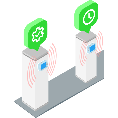
iBeacon beacons consume minimal energy with BLE positioning, which allows them to run on battery power for several years and significantly save on maintenance.

Easy to install
BLE beacons are easy to install and do not require complex configuration. Installation is carried out on double-sided adhesive tape to the walls and without connecting to the power supply.
Indoor navigation provides high accuracy by supporting a variety of standards and equipment: iBeacon (Bluetooth), Wi-Fi, AoA (BLE), UWB, RFID, QR, AR, etc.
The infrastructure for location determination is deployed in the premises - iBeacon beacons, Wi-Fi access points, AoA locators, UWB receivers, navigation racks that emit special signals. These signals are received by mobile devices and allow you to determine the exact location.


The infrastructure for location determination is deployed in the premises - iBeacon beacons, Wi-Fi access points, Aaa locators, UWB receivers, navigation racks that emit special signals. These signals are received by mobile devices and allow you to determine the exact location.
Using the web control panel and a graphical editor, a 3D map of the building and its premises is created, names and descriptions are entered, the location of the equipment, routes, location zones, and so on are plotted.


The API with a detailed description integrates quickly with corporate systems, and the iOS and Android SDK make it easy to integrate into any mobile application and CRM system.
A detailed history of object visits, tracking of movement routes, time spent in zones and other activities is collected in a database with an access control function.


To solve marketing problems and send targeted messages, taking into account the analytical data and the user's profile, the corresponding section of the service is used.
Thematic publications on our blog

Synergy of technologies and new INP features
As part of the implementation of the initiatives of the National Technology Initiative (NTI), the Aeronet project occupies a special place aimed at developing advanced technologies in the field of unmanned aerial vehicles, navigation systems and geoinformation solutions. As a leading developer of indoor navigation and asset management solutions, Interiors Navigation makes a significant contribution to achieving Aeronet's goals. Our innovative developments, in particular the Indoor Navigation Platform (INP), not only meet the requirements of the roadmap, but also open up new perspectives for the use of unmanned vehicles in enclosed spaces.

We provide information about all the features of our platform with a detailed description of API and SDK integration.

Support
To save developers time, we provide consultations and technical support 24/7.
