Modern navigation in theaters

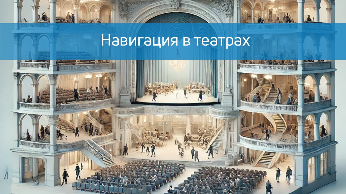
A visit to the theater is always a celebration of art and culture. However, in large and modern theaters, visitors often face problems that can make it difficult to fully enjoy the event: finding the right room, confusing routes, long queues at the cloakroom or buffet. Modern navigation technologies are able to solve these problems, making visiting the theater comfortable and unforgettable, and making the work of employees more efficient.

In this article, we will look at why modern navigation systems are necessary for theaters, how they help visitors and staff, and what their role is in improving operational processes.

Why do modern theaters need navigation systems?

Modern theater buildings are often complex architectural structures with multiple floors, zones, and specialized rooms. This can cause difficulties for both visitors and employees.

  1. Complicated routes. Visitors may have difficulty finding the right room, cloakroom, toilet, or buffet. This is especially true for large theaters with multiple stages or international theaters where orientation is complicated by the language barrier.
  2. Reduction of adaptation time. Often, the audience arrives at the theater a few minutes before the start of the performance, which makes the search for a place even more stressful. Modern navigation helps you quickly and accurately get to the right point.
  3. Problems for low-mobility groups of the population. Theaters are required to take into account the needs of people with disabilities. Traditional signs and routes often do not provide comfortable movement for such groups.
  4. Reducing the burden on staff. In the absence of a navigation system, visitors are forced to turn to staff for help. This distracts staff from other tasks and creates additional queues.

How do modern navigation systems help visitors?

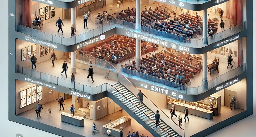
1. Intuitive theater map

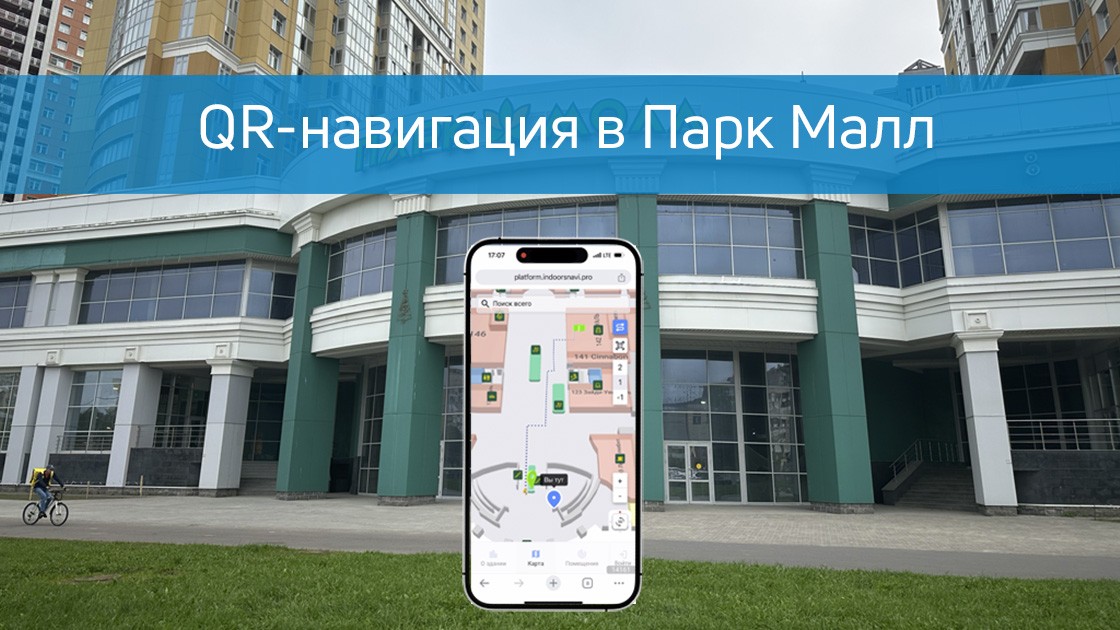
Electronic navigation provides visitors with the opportunity to explore the map of the building in real time, including all halls, buffets, wardrobes, toilets, recreation areas and additional services. The visitor can independently choose a route that will be displayed on his device or information kiosk.

2. Setting routes to places

The system allows you to quickly find your way to your seat in the auditorium. The visitor enters the number of the ticket or row, and the system plots a convenient route. This is especially convenient for people who visit the theater for the first time and are not familiar with its structure.

3. Multilingual interface

For foreign guests, the systems offer an interface in several languages, which facilitates their orientation and makes the visit pleasant.

4. Solutions for people with limited mobility

Navigation is integrated with information about accessible routes for people with disabilities, including ramps, elevators and special places. This significantly improves the accessibility of the theater and shows concern for inclusivity.

5. Timely information

The system can notify visitors about the start time of the performance, the upcoming breaks, and the workload of buffets or cloakrooms. This helps viewers to plan their time rationally.

Benefits for employees and administration

Modern navigation systems facilitate the work of theater staff and help the administration improve operational processes.

1. Reducing the burden on staff The system removes some of the burden from the wardrobe staff, supervisors and administrators. Visitors can independently find the necessary information and route, which reduces the number of questions to the staff.

2. Managing the flow of visitors With the help of the system's analytics, the administration can monitor the audience flows in different areas of the theater. This allows you to predict in advance the workload of certain sites and redistribute staff.

3. Feedback from visitors The system may include the ability to leave feedback about a visit. This helps to identify problem areas and work on their elimination.

4. Analytics and statistics The navigation system collects data on the movements of visitors and their time spent in different zones. This helps the administration to optimize the location of services and improve the customer experience.

5. Saving resources Automation of navigation reduces the cost of paper signs and additional information stands.

Usefulness for users

Modern navigation makes visiting the theater comfortable for all categories of users.:

  • For frequent visitors. The system saves time and allows you to focus on the main goal — to enjoy art.
  • For beginners. People visiting the theater for the first time receive detailed instructions and routes, which relieves stress and makes their visit enjoyable.
  • For foreign guests. The interface in several languages helps to avoid the language barrier.
  • For people with disabilities. Well-thought-out routes make the theater accessible to everyone.

Usage examples

  1. A theater with several halls. If the theater is hosting performances on different stages at the same time, navigation helps each viewer quickly find the right place.
  2. Events with a large number of visitors. On premiere or tour days, the system helps manage large flows of people, minimizing queues and delays.
  3. Interactive features. Navigation can be complemented by the ability to book buffets or cloakrooms through the app, which saves viewers time.

Conclusion

Modern navigation in theaters is not just a convenience, but an important element that improves the quality of service and work efficiency. It makes visiting the theater comfortable for the audience and helps the staff to focus on their tasks.

The introduction of such technologies demonstrates concern for visitors and strengthens the theater's reputation as an innovative and client-oriented cultural institution. With Indoors Navigation, your theater will become a place where the audience will come back again and again!

Interactive navigation in the clinic Be Healthy with face recognition.

The Indoors Navigation team has deployed a system for tracking the movement of personnel and medical equipment in the showroom of the official distributor of professional medical equipment, Techno Medicine Company.

В нескольких помещениях было установлено оборудование — приемники для считывания сигнала от меток (NaviTagThe project used Ultra-WideBand technology, which made it possible to achieve high positioning accuracy of up to 0.5 meters. 

Now, in real-time mode, companies can observe how the equipment is moving, view the history of routes and conduct demonstrations of new technologies.

For more information about the company and its products, you can visit our website.: https://indoorsnavi.pro/


Discover the future of geographic information systems with the Indoors Navigation Platform. 🌐

📍 What will you see?

The digital twin of the enterprise in action

Indoor geolocation services

Interactive navigation with QR codes and AR

🛠 How to integrate it?

We create personalized solutions for each client. Contact us for a demo.

👇 Subscribe and keep up to date with innovations! 👇

Learn more about new developments and the geographic information system of the Indoors Navigation Platform: https://indoorsnavi.pro/

NTV story about Indoors decision for people with disabilities

The NTV channel's news program Today featured a story about the Indoors Navigation solution for people with disabilities at railway stations.

This video shows how our navigation system helps people with limited mobility (MH) easily navigate complex transport hubs, find the right platforms, ticket offices and exits.

How modern technologies make train stations more accessible and travel safer and more comfortable for all passengers!"


Единая информационная среда для управления зданиями и активами — геоинформационная система (ГИС) на основе цифрового двойника объекта и геолокационных сервисов внутри помещений Indoors Navigation Platform (INP).

Learn more on the website www.indoorsnavi.pro

Discover the future of geographic information systems with the Indoors Navigation Platform. 🌐

📍 What will you see?

The digital twin of the enterprise in action

Indoor geolocation services

Interactive navigation with QR codes and AR

🛠 How to integrate it?

We create personalized solutions for each client. Contact us for a demo

👇 Subscribe and keep up to date with innovations! 👇

Learn more about solutions based on the geographic information system of the Indoors Navigation Platform

For more information about navigation in public places, follow the link: https://indoorsnavi.pro/

Navigation in schools and educational institutions

As part of the implementation of the initiatives of the National Technology Initiative (NTI), the Aeronet project, modern educational institutions face numerous challenges related to safety, process management and efficiency improvement. The introduction of navigation and motion tracking systems is becoming one of the key tools to help solve these problems. In this article, we will look at how such systems can be used in schools and other educational institutions, what technologies underlie them, and how they affect the safety of students and staff.

The use of navigation and motion tracking systems in schools and educational institutions covers several key areas:

  1. Ensuring security The systems allow real-time tracking of the location of students and staff, which is especially important in case of emergencies such as fires or terrorist threats. The ability to quickly determine where the children are significantly increases the chances of timely evacuation and risk minimization.
  2. Tracking attendance Automation of attendance tracking is one of the main advantages of navigation systems. Instead of the traditional manual marking of attendance in lessons, the system automatically records the presence of students based on their movements inside the building.
  3. Logistics optimization Navigation systems help manage the flow of students and staff, avoiding crowds in the corridors, especially during recess. It also helps to reduce the likelihood of conflicts and accidents.
  4. Improving access security In schools where access security is a high priority, such systems can integrate with access control systems (ACS), providing movement monitoring and preventing unauthorized entry.
  5. Navigation for new students and visitors On large academic campuses, navigation systems help new students and visitors navigate the building, find the necessary classrooms and halls, which is especially important in the first weeks of the academic year.

Strengths of navigation systems:

  • Increased security.
    The main advantage is a significant increase in security. In case of emergencies, the system allows you to accurately determine the location of each student, which greatly facilitates evacuation.
  • Automation of processes.
    Navigation systems automate many routine processes, such as attendance records, which saves time and reduces the likelihood of errors.
  • Transparency and control.
    Such systems ensure complete transparency of movements inside the building, which helps to improve discipline and control over the educational process.

Weaknesses of positioning systems:

  • Privacy issues.
    One of the main issues is the protection of personal data and confidentiality. Movement tracking systems require processing a large amount of personal information, which may cause concern among parents and staff.
  • Implementation and maintenance costs.
    The installation and maintenance of such systems requires significant financial investments. This includes both the initial equipment costs and the ongoing costs of system maintenance and upgrades.
  • Resistance from users.
    Not all users may be ready to adopt such technologies, especially for systems that require constant monitoring of their movements.

Impact on security

Navigation and motion tracking systems have a significant impact on the safety of educational institutions. They allow administrators to respond quickly to emergencies, ensuring more effective evacuation management and minimizing risks to students' lives and health.

In addition, such systems help to prevent unauthorized access to the territory of the educational institution, which is especially important in the context of increasing security threats. In the long term, the introduction of such systems contributes to the creation of a safe educational environment, which has a positive effect on the overall level of trust in the educational institution.

Technologies and their application

Navigation and motion tracking systems in schools use a variety of technologies, including BLE beacons, Wi-Fi, RFID, and ultra-broadband (UWB) systems. These technologies allow you to accurately determine the location of students and staff inside the building, as well as track their movements in real time.

Our platform supports integration with BIM (Building Information Modeling), construction management Systems (CMS) and ERP systems, which allows you to create a single information space for managing facilities and assets. In addition, the open API of the Indoors Navigation Platform provides the ability to integrate with various UAV control systems, which makes our platform a universal solution for navigation and control tasks within the Aeronet implementation.

Application of the Indoors Navigation Platform in smart cities and transport hubs

As part of the Aeronet implementation, special attention is being paid to the development of technologies for smart cities and transport hubs. The Indoors Navigation Platform provides all the necessary tools to create modern navigation systems in such conditions. The platform allows you to manage the flow of people and vehicles, monitor the state of the infrastructure and ensure safety at facilities.

Performance criteria

The effectiveness of navigation and motion tracking systems is determined by several key factors:

  • Positioning accuracy.
    This is the main indicator of the system's effectiveness, especially in critical situations. The positioning accuracy must be high enough for the system to accurately determine the user's location inside the building.
  • Reliability and stability of the system.
    It is important that the system works stably even under heavy load or in conditions where the signal may be weakened (for example, in multi-storey buildings or in buildings with thick walls).
  • Integration with other systems.
    Effective navigation and tracking systems should be easily integrated with the existing management systems of the educational institution, including security systems, access control and training schedules.
  • Ease of use.
    The user interface should be intuitive and user–friendly, both for administrators and for end users - students and staff.

And what happened in the end

Navigation and motion tracking systems are becoming an integral part of the modern educational process, especially in large schools and universities. These technologies help to significantly improve safety, optimize learning processes and ensure a comfortable and safe stay of students in educational institutions.

The Indoors Navigation Platform offers comprehensive solutions for schools and universities that can be adapted to the specific needs of each institution. High accuracy, ease of use, and integration with existing systems make Indoors Navigation a reliable partner in creating a safe and effective educational environment.

If you would like to learn more about the possibilities of the Indoors Navigation Platform for your educational institution, please contact us for advice and demonstration of the platform's capabilities. Our experts will help you choose the optimal solution that meets all your requirements.

Learn more about the application of Indoors Navigation solutions for positioning on the construction site on our on the website .

Navigation at Kostroma railway station

In September 2024, Indoors Navigation successfully completed a project to digitize and implement a passenger navigation system on Kostroma railway station. This project has become part of the overall digitalization program of Russian railway facilities aimed at improving passenger convenience and safety.

The main goal of the project was to create a convenient and intuitive navigation system that would allow passengers to quickly find the necessary facilities at the station, such as platforms, ticket offices, recreation areas and other important infrastructure facilities.

The project also included the digitization of the station with the creation of a digital twin, which allows both passengers and the administration to effectively interact with data about the station in real time.

The Indoors Navigation project in Kostroma has shown that the introduction of modern navigation systems at transport facilities can significantly improve the quality of passenger service. The system allows you to optimize the management of the facility, improve the organization of passenger flows and provide convenient navigation tools.

Indoors Navigation Platform — It is a universal solution for transportation facilities that will help you improve navigation and management. Contact us for a consultation and find out how our system can improve your train station or transport hub.

Discover the future of geographic information systems with the Indoors Navigation Platform. 🌐

📍 What will you see?

The digital twin of the enterprise in action

Indoor geolocation services

Interactive navigation with QR codes and AR

🛠 How to integrate it?

We create personalized solutions for each client. Contact us for a demo.

👇 Subscribe and keep up to date with innovations! 👇

Interactive map of the Park Mall shopping mall

In St. Petersburg, we have launched interactive navigation in the Park Mall shopping and entertainment complex. The visitor does not need to install a mobile application to get acquainted with the map of the shopping mall and the location of the shops, or to set a route to the restaurant of interest.

It is enough for the user to scan the nearest QR code on the wall and a map with a marked location will open in the phone browser. Having found the desired point of interest through the search, the user will get the shortest route to it.

QR-навигация в торговых центрах — один из наиболее доступных и удобных способов помочь посетителя сориентироваться, понять свое местоположение и найти нужный магазин в ТЦ.

For more information about the company and its products, you can visit our website.: https://indoorsnavi.pro/


Discover the future of geographic information systems with the Indoors Navigation Platform. 🌐

📍 What will you see?

The digital twin of the enterprise in action

Indoor geolocation services

Interactive navigation with QR codes and AR

🛠 How to integrate it?

We create personalized solutions for each client. Contact us for a demo.

👇 Subscribe and keep up to date with innovations! 👇

Learn more about new developments and the geographic information system of the Indoors Navigation Platform: https://indoorsnavi.pro/

Augmented Reality navigation

In today's world, where navigating large and crowded spaces can be a real challenge, Indoors Navigation offers an advanced augmented reality (AR) navigation solution. This technology allows users to see routes directly in real space through the screen of their smartphone, making the process of movement easier and intuitive.

Using the Indoors Navigation Platform, users can scan special markers to get visual cues integrated into the environment using 3D graphics. This is especially useful in places with high density of people, such as train stations and shopping malls, where traditional maps may not be informative enough.

AR navigation also opens up new business opportunities: virtual elements can not only point the way, but also serve as a channel for creative advertising, attracting users' attention and creating new opportunities for brand interaction.

The benefits of Augmented Reality navigation:

  • Интуитивность и удобство — ользователи получают маршрут прямо перед собой, что исключает необходимость отвлекаться на чтение карт и схем.
  • Интерактивность — иртуальные объекты можно использовать для продвижения брендов, что делает навигацию не только полезной, но и увлекательной.
  • Современность — AR-навигация представляет собой шаг в будущее, где технологии и реальность сливаются воедино, создавая новый уровень комфорта и безопасности.

Disadvantages:

  • Зависимость от устройства — работа AR-навигации требует достаточно мощного смартфона, что может ограничить круг пользователей.
  • Необходимость маркеров — для активации AR-навигации требуются специальные маркеры, что может усложнить использование технологии в некоторых случаях.

AR navigation from the Indoors Navigation Platform is not just a technological innovation, but a real tool for improving convenience and safety in high-traffic areas. This technology allows for seamless integration of the virtual and real worlds, opening up new opportunities for both users and businesses.

Learn more about how the Indoors Navigation Platform can transform your facility and offer your visitors a new level of comfort and safety. Contact us for a consultation and demonstration of the platform's capabilities.

https://indoorsnavi.pro/

👇 Subscribe and keep up to date with innovations! 👇

Synergy of technologies and new INP features

As part of the implementation of the initiatives of the National Technology Initiative (NTI), the Aeronet project occupies a special place aimed at developing advanced technologies in the field of unmanned aerial vehicles, navigation systems and geoinformation solutions. As a leading developer of indoor navigation and asset management solutions, Indoors Navigation makes a significant contribution to achieving Aeronet's goals. Our innovative developments, in particular the Indoors Navigation Platform (INP), not only meet the requirements of the roadmap, but also open up new perspectives for the use of unmanned vehicles in enclosed spaces.

Contribution of Indoors Navigation to the realization of Aeronet's goals

The Aeronet project is aimed at creating integrated systems that ensure high accuracy of navigation and control of unmanned aerial vehicles (UAVs). One of the key tasks is to develop technologies that make it possible to effectively use UAVs not only in open spaces, but also in enclosed spaces. It is in this aspect that the Indoor Navigation solutions play an important role.

The Indoors Navigation Platform, based on the use of digital object doubles and advanced geolocation services, provides high accuracy of positioning and navigation inside buildings. This platform allows the drone to move safely and precisely indoors, providing unprecedented opportunities for automation of various processes, including logistics, inspections and monitoring.

The possibilities of using the Indoors Navigation Platform for UAVs

INP is a comprehensive geographic information system capable of operating in confined spaces where traditional navigation methods such as GPS are losing their effectiveness. The platform uses BLE (Bluetooth Low Energy), UWB (Ultra-Wideband) technologies, and integrates video analytics and machine learning algorithms, which ensures high accuracy and reliability of positioning drones in all conditions.

For example, in large logistics centers or industrial enterprises where it is necessary to automate the movement of goods or monitor the state of infrastructure, the use of unmanned vehicles integrated with the Indoors Navigation Platform can significantly increase efficiency and reduce costs. The platform ensures accurate route tracking, obstacle avoidance and timely completion of tasks, which is especially important in conditions of limited space and high density of objects.

Digital twin as a basis for indoor navigation

One of the key elements of the Indoors Navigation Platform is the use of digital twin technology. A digital twin is a virtual copy of a physical object or infrastructure that is synchronized with the real world and updated in real time. This allows unmanned vehicles to navigate in space with high accuracy, using data on the current state of the object, its characteristics and changes.

The digital twin not only provides indoor navigation, but also provides data for process analysis and optimization. For example, in the case of infrastructure monitoring, drones can use digital twin data to detect problem areas, plan inspection routes, and automatically send reports if deviations from the norm are detected. This is especially important in the context of Aeronet's objectives aimed at improving the safety and efficiency of UAV use.

Synergy with the Aeronet roadmap

One of the key aspects of the Aeronet project is the creation of an ecosystem that integrates various technologies and solutions. The Indoors Navigation Platform fully meets these requirements, offering flexibility in configuration and integration with existing control and navigation systems.

Our platform supports integration with BIM (Building Information Modeling), construction management Systems (CMS) and ERP systems, which allows you to create a single information space for managing facilities and assets. In addition, the open API of the Indoors Navigation Platform provides the ability to integrate with various UAV control systems, which makes our platform a universal solution for navigation and control tasks within the Aeronet implementation.

Application of the Indoors Navigation Platform in smart cities and transport hubs

As part of the Aeronet implementation, special attention is being paid to the development of technologies for smart cities and transport hubs. The Indoors Navigation Platform provides all the necessary tools to create modern navigation systems in such conditions. The platform allows you to manage the flow of people and vehicles, monitor the state of the infrastructure and ensure safety at facilities.

For example, at airports and train stations, the Indoors Navigation Platform can be used to automatically monitor the movement of UAVs, ensuring effective inspection and monitoring tasks. This makes it possible to significantly reduce infrastructure maintenance costs and increase security, which is consistent with the objectives of the Aeronet roadmap.

And what happened in the end

The Indoors Navigation Platform opens up new opportunities for the implementation of the tasks of the Aeronet NTI roadmap. Our solutions ensure high accuracy and reliability of indoor navigation, which is especially important for the use of unmanned aerial vehicles in enclosed spaces. The implementation of our platform allows us to significantly increase the efficiency of using UAVs, reduce costs and ensure safety at facilities.

The company Indoors Navigation continues to actively develop its technologies, supporting NTI initiatives and offering innovative solutions for smart cities and transport hubs. Our products have already proven their effectiveness on a number of major projects, and we are confident that their potential will be in demand as part of the implementation of Aeronet and other initiatives aimed at Russia's digital transformation.

Learn more about the application of Indoors Navigation solutions for positioning on the construction site on our on the website .

Application of positioning and tracking of construction workers

Modern construction sites are becoming more complex and large-scale. To manage these facilities effectively, developers and builders need to use advanced technologies. One of these technologies is the worker positioning and tracking system. These systems allow for improved process control, lower costs, and increased safety and productivity.

Various technologies are used on construction sites to position and track workers. The main ones include GPS and GLONASS, RFID, Bluetooth, UWB, Wi-Fi, and computer vision cameras. Each of these technologies has its advantages and disadvantages, depending on the conditions and requirements of a particular project.

GPS and GLONASS

Global positioning systems such as GPS and GLONASS are widely used on outdoor construction sites. These technologies allow you to accurately determine the location of workers and equipment in an open area. However, in conditions of dense buildings or inside buildings, their accuracy may decrease.

RFID

Radio Frequency identification (RFID) is a technology where RFID tags are attached to workers' hard hats, clothing, or equipment. Readers installed at certain points record the passage of tags, which allows you to track the movements of personnel. This solution is convenient for access control and time management.

Bluetooth и BLE

Bluetooth and BLE (Bluetooth Low Energy) technologies are used to create networks of beacons that interact with workers' mobile devices. These technologies ensure high accuracy of positioning inside buildings, which makes them ideal for use in dense buildings.

UWB

Ultra-Wideband (UWB) is a technology that provides high positioning accuracy of tens of centimeters. It is especially effective in dense buildings and enclosed spaces where GPS accuracy may be insufficient.

Cameras and computer vision

Modern video surveillance systems using computer vision technologies can analyze the movements of workers and equipment in real time, detect violations and prevent accidents. Cameras can be placed at key points, providing visual monitoring of what is happening on the site.

Advantages for developers

The implementation of worker positioning and tracking systems brings many benefits to developers and builders. These systems can improve security, improve resource management, increase productivity, and reduce costs.

Increased security

Safety on the construction site is a priority. Tracking systems allow you to quickly respond to emergency situations, identify potential hazards in a timely manner and prevent accidents. For example, with the help of positioning systems, it is possible to control the access of workers to dangerous areas and evacuate them in a timely manner if necessary.

Increased productivity

Collecting data on workers' movements and activities helps optimize work processes, reduce downtime, and increase overall productivity. For example, data analysis can identify bottlenecks in logistics and suggest ways to eliminate them, which reduces the time needed to complete tasks.

Cost reduction

Automated control over the execution of work allows you to reduce the cost of management and control, as well as minimize losses associated with inefficiency and errors. According to research, the use of positioning and tracking systems can reduce workflow management costs by 10-20%. For example, if a project costs $100 million, the savings can be up to $20 million.

Improved resource management

Tracking systems help to efficiently distribute labor and equipment, avoiding their downtime and overloads. This makes it possible to use resources more efficiently and reduce the cost of their maintenance.

Documentation and reporting

Automatic logging and reporting simplifies the documentation process and allows you to quickly provide the necessary information to customers and regulatory authorities. This reduces the administrative burden and increases the transparency of the processes.

Metrics and achieved results

Various metrics such as labor productivity, security level, task completion time, and management costs are used to evaluate the effectiveness of positioning and tracking systems implementation. Examples of achievable results include:

  • Increase in labor productivity by 15-25%.
  • Reduce the number of accidents by 30-40%.
  • Reduce task completion time by 20-30%.
  • Reducing project management costs by 10-20%.

Integration with existing solutions

Modern positioning and tracking systems can be integrated with existing construction management solutions and geographic information systems such as the Indoors Navigation Platform. This allows you to create a unified information space and ensure more effective project management.

Integration with BIM (Building Information Modeling)

Tracking systems can be linked to BIM, which allows you to automatically update building models and monitor the execution of work in accordance with the design documentation. This simplifies the process of planning and coordinating work.

Integration with Construction Management Systems (CMS)

The introduction of tracking technologies in CMS allows for improved project planning, control, and reporting, providing more accurate data for management decision-making. This allows you to reduce decision-making time and improve their quality.

Integration with ERP systems

Integration with ERP (Enterprise Resource Planning) systems helps automate accounting and resource management, including labor, equipment, and materials. This allows you to reduce the cost of managing resources and increase their efficiency.

The use of geographic information systems (GIS)

Combining data on the location of workers with GIS cartographic data allows for more accurate planning of work and improved logistics at the construction site. This helps to reduce the time needed to complete tasks and reduce logistics costs.

Indoors Navigation solutions for process and personnel control

The company Indoors Navigation offers comprehensive solutions for monitoring processes and personnel on construction sites. Our systems include the Indoors Navigation Platform, mobile applications for workers, analytical tools and solutions for integration with other systems.

The Indoors Navigation Platform

Our platform allows you to integrate various positioning and tracking technologies into a single system, providing accurate and reliable control over all aspects of the construction process. It supports integration with BIN, CMS, ERP and GIS, which allows us to use our technologies within the existing customer infrastructure.

Mobile applications for workers

User-friendly mobile applications allow workers to receive up-to-date information about assignments, routes, and safety, as well as provide real-time data for supervisors. This helps to improve communication and coordination of work.

Analytical tools

Our analytical tools help analyze the collected data, identify trends, and make informed decisions to optimize processes. This makes it possible to increase the efficiency of project management and reduce costs.

Integration with other systems

We offer solutions for integration with BIM, CMS, ERP and GIS, which allows us to use our technologies within the existing customer infrastructure. This simplifies the implementation process and increases the efficiency of using our solutions.

Conclusion

The introduction of positioning and tracking systems for workers on construction sites opens up new opportunities for developers and builders. These technologies help to increase security, improve process management, and reduce costs. The company Indoors Navigation offers advanced solutions that integrate with existing systems and provide full control over all aspects of construction. Contact us to learn more about our products and begin the path to more efficient and safer construction.

Learn more about the application of Indoors Navigation solutions for positioning on the construction site on our on the website .

How digital maps help developers sell real estate.

In today's digital world, successful real estate sales require an innovative approach. Digital maps of facilities, such as those offered by Indoors Navigation, are becoming an integral part of the developers' strategy. Let's look at how these cards can help you sell real estate.

Digitalization of buildings

Digitalization of buildings significantly increases the efficiency of the sale of real estate. It allows you to create accurate and interactive visual representations of objects, which helps potential buyers to better understand the layout and features of the property even before a physical visit. The use of digital doubles and 3D models enables virtual tours, which creates a more realistic impression of the space. This makes the purchase process more convenient, reduces decision-making time, and increases customer satisfaction by providing them with access to information at any time and from any location.

Advantages of digital cards

1. Visualization of space

Digital maps allow potential buyers to visualize the space of an object in an interactive format. They can view room layouts, floor layouts, and key points such as elevators, stairs, and exits. This helps buyers to better understand the layout and features of the property even before visiting the facility.

2. Interactive 3D models

Использование 3D-моделей здания предоставляет более глубокое погружение в объект. Покупатели могут «прогуляться» по цифровому двойнику здания, увидеть виды из окон и оценить пространство с различных ракурсов. Это создает более реальное впечатление и помогает в принятии решения о покупке.

3. Improved presentation of objects

Digital maps allow developers to create detailed presentations of their properties. They can be used to easily demonstrate the benefits of location, infrastructure, and available amenities. This is especially important when selling real estate during the construction phase, when physical access to the property is limited.

4. Data collection and analysis

The integration of digital maps with analytics systems allows developers to collect data on user behavior. Information about which areas of the map users view the longest can help in identifying the most attractive areas and improving marketing strategies.

5. Convenience for customers

Digital cards make the process of buying real estate more convenient and transparent. Buyers can explore the facility at any time and from any location using their devices. This reduces travel and meeting time, increasing customer satisfaction.

Usage examples

Внедрение «Умного ЖКХ» может значительно улучшить качество жизни жильцов. Во-первых, оно позволяет экономить на коммунальных платежах за счет оптимизации потребления ресурсов. Во-вторых, умные Indoors Navigation успешно внедряет цифровые карты в своих проектах. Например, создание цифровых двойников для жилых комплексов позволяет девелоперам демонстрировать планировки квартир и общих зон, а также предоставлять виртуальные туры для потенциальных покупателей.

Conclusion

Digital object maps are a powerful tool that helps developers effectively sell real estate. They provide visualization of space, interactive 3D models, improved presentation of objects, data collection and analysis, as well as convenience for customers. By implementing such technologies, developers can increase their competitiveness and meet the needs of modern buyers.

Let's simplify customer interaction together and make a convenient service for them.

You can learn more about the technologies on our website. on the website Indoors Navigation.

#secondary

Обращение успешно отправлено!